Thursday, October 17, 2013

Killington

As I came out of the Green Mountain N.F. toward Rutland there were definitely more signs of civilization: farms, road crossings, power lines. But, almost ominously to the north, looms Killington Peak.

Although at just under 4000' Killington is not Vermont's highest peak, it towers over the surrounding area, sitting alone among a bunch of 2000-footers. Fortunately the trail leading up to Killington is pretty gradual and graded for the most part even though there is a net elevation gain of 2800'.
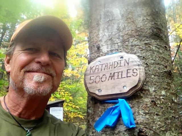
I was happy to pass one milestone in this section: the countdown to being less than 500mi from Mt Katahdin. Seems like a long way yet but I've already gone 1700mi so it actually seems attainable now.
I had planned my arrival at the top of Killington so that I could watch the sunset from its 360ยบ view but Mother Nature had other plans, giving me another grey, cloudy day. Killington is also famous for being a highly developed ski resort but fortunately, the AT crews have routed the trail along the opposite edge of the peak and down several hundred feet. Even though there's a gondola that transports more sedentary travelers to the top, I had Killington all to myself on that gloomy Friday evening.

I was due for a trail stop to rest and resupply so I decided to treat myself to a night at The Inn at Long Trail. It's a little off the AT but right on what used to be the Long Trail, run by the McGrath family since the 30s. Although they've maintained the rustic feel of a mountain lodge, there's an understated luxury with great food, a lounge, and even a hot tub! They are super hiker-friendly folks too. Another bonus is that there's a bus line that runs into Rutland every hour (about 10mi) so it was pretty easy to find supplies and a few treats as well.
I was pleasantly surprised at the resources Rutland offered. It was obviously a sizable, vital hub in the past of timber and industry but has reinvented itself through some tourism. I was happy to find a really nice food co-op and a local coffee roaster. Civilization ain't all bad :)


Tuesday, October 15, 2013

More Long Trail Views

Fortunately, I had some great weather during most of my time on the Long Trail: Clear, sunny days and cool nights. It was little warm for my hiking style but I still was able to make 18-20mi per day and still have time to stop and appreciate some of the views. On the AT, many of the "views" are not necessarily a sweeping panorama from a high peak but the more subtle things one sees while quietly traversing the forest. Like this foot bridge...
I noticed each day as I headed north that more Fall color was showing, especially at higher elevations. It's amazing how much of a difference one sees in just 100mi from Mass into Vermont during transitional seasons.
Considering how nice the weather is in early Fall, I saw relatively few other hikers on the AT. Most of the long-distance hikers I saw were either going south on the Long Trail (270mi from the Canadian border to MA) or going south completing a flip-flop hike of the AT. There were a few other section hikers doing small pieces to the north but we were really near the end of the season for that.
Another interesting feature of Vermont (and really much of the trail from NJ north) is the number of high elevation ponds and bogs. Because so much of the mountains are solid granite and non-porous, wherever there is a dip or a bowl in the rock, soil and/or water collects and forms it's own ecosystem.
Some are tiny little pools, but often large ponds a half mile across might be seen above 2000'.
And streams! Even without rain for weeks, no shortage of water in Vermont.
Nothing like waking up to a view like this.


Tuesday, October 8, 2013

Southern Vermont

The section of AT from Rt9 at Bennington to Killington is my favorite in the north so far. The trail traverses several wilderness areas and I pretty much stayed away from civilization for 5 days. Not even cell service! The AT shares the same trail bed as Vermont's old Long Trail for over 100 miles through the Green Mountain National Forest. The AT is noticeably more primitive: less blazing and blowdown removal, in places fairly tricky to follow.

The AT gets considerably more rugged with a lot of ups and downs. There are several big climbs to peaks just under 4000' which I haven't seen since central VA. Beautiful country.

One of the highlights of this section is the view from Stratton Mt. Firetower. Fortunately I hit it on a clear day. At this location Benton McKaye is storied to have formulated the idea for the AT.
Among the higher peaks in this region are Glastenbury, Mt Stratton, Mt Bromley, and Peru Peak. I noticed above 3000' that the forest changes to a sub-alpine mix of spruce and a rich mix of mosses and ferns. I love the elfin trails through the green.

Saturday, October 5, 2013

Bennington


Although I stayed less than 24 hours, I found most of what I needed in Bennington. The town is surrounded by mountains, maybe 5 mi or so off the AT.
It's a cute little trail town but looked like it had seen better days. A lot of history there too. The highlight for me was getting to a meeting in the heart of Bill W. land. Strong medicine indeed. However, I strongly recommend avoiding the Autumn Inn at all cost. It was an overpriced shithole. So there.

Sunday, September 29, 2013

Into Vermont

After a quick detour for breakfast in N. Adams, I marched up the long climb from Rt2 to the Vermont border. It was sunny and on the warm side so by the time I'd made the 2500' climb I was drenched. But it always feels good to check off another state. Entering Vermont, the AT follows the old Long Trail for over 100mi.
Vermont definitely offers some higher, more wild terrain than I've seen in a while. But before tackling the Green Mountain NF, I need one more pit stop in Bennington to regroup.
View of Bennington from Harmon Hill south of Rt 9.

Foiled Again

After all the anticipation on my part, the big climb up Mt Greylock yielded only a view of whiteout. The weather has been fantastic overall--sunny, mild, clear--but Saturday was overcast and grey. By the time I sumitted Greylock it was foggy, drizzling, and 42degrees.
Fortunately, the lodge was open and offered hot coffee and a space to warm up. It was tempting to stay overnight considering the conditions, but considering I'd just had a town day I was anxious to move on.

True to form, the next morning cleared and I got these great views looking north across the Hoosic River into Vermont.

Thursday, September 26, 2013

Greylock in View

Alrighty. Finished my first little section today: 58mi in 4 days to Cheshire MA. Stopped in Dalton this morning for breakfast at "Juice and Java", an excellent coffee shop/deli. Both Dalton and Cheshire are sweet little trail towns. A lot more friendly and accommodating than a certain other Berkshire town I won't mention again.

Except for Mt Everett, I've been in low elevation since Shenandoah some 600 miles back (nothing over 2000'). But now Mt Greylock looms in the foreground, the highest point in MA. The climb doesn't look too bad, but it is 2200' of elevation gain so I'd better buckle down. The weather looks to be staying clear so looking forward to the view from the top.
View of Greylock from Warner Hill, about 20 mi south

Upper Goose Pond Cabin

Thanks to a hot tip from a couple trail maintainers, I decided to check out the ATC run and operated Upper Goose Pond Cabin. Being only my 2nd night in, I really wanted to acclimate to the outdoors but they said I shouldn't miss it. Boy, were they right!
When they said "cabin" I visualized something a lot simpler. While there was no electricity or running water, UGPC had a nice cooking area, a large stone fireplace inside, and an incredible view of the pond from the upstairs bunk house. Plus hot coffee and pancakes for breakfast--I sure am glad I didn't miss it.

And so it begins...again.

Finally got my feet on the Trail Monday (9/23) around 10. So much last-minute stuff to get squared away. It's always a relief for me to get the pack on and just start walking, leaving all that worldly stuff behind (temporarily at least).
 What a difference a year makes. Last year's hike ended so miserably in the rain coming down Mt Everett. This year the weather was sunny, breezy, and crisp. This view of Mt Everett doesn't even look like the same mountain I (never) saw. For me, hiking is ideal when daytime temps are in the mid-50s and nighttime in the 30s. Makes for relatively un-sweaty climbing and great sleeping at night. So far, looks like this whole week is gonna be awesome.  Just gotta get my trail legs and lungs.

And BTW, the Mass ATC does a fantastic job maintaining their section of AT (take note NY & PA).

Great Barrington

Back where I finished on Oct 4th last year, in Great Barrington MA. It's a pretty sweet little town--nice food Co-Op, some interesting restaurants and shops.
 Asia Barong--amazing selection of Buddhist and Hindu imported goods including GIANT statuary.
It's no Salsas, but some pretty hip Cont-Mex digs. But for all the amenities GB is pretty upscale and not all that hiker-friendly. Expensive, a distance from the Trail, and well, just not that helpful. Nonetheless, a nice place to land on that gentrified US7 corridor.

When I wrapped up my hike last year, I had been in the rain for a week and slipped twice--once coming down Bear Mt (CN border) bruising my tailbone, and again on top of Mt Everett breaking my camera. So, enough was enough. I just heard that a young hiker fell to his death on Race Mt. (between those two) just a few weeks ago. Wet rocks, AT perilously close to the edge of massive cliffs. I was scared and now I see it wasn't just over reaction. And for all that climbing I had not one view because of white out from the clouds. I was tired of wetness and falling and getting ground up, so that was the end of the 2012 hike. Even though I did 500mi in a little over a month, I was beat up. So things are looking better this go around. Some clear weather ahead and a fresh start.

Sunday, September 22, 2013

Back in The Berkshires

I made the long drive up to New England today from Asheville--12+hrs.--but totally worth it. The colors are starting to show as soon as I hit The Taconic State Pky. Looks like a beautiful week ahead for hiking: mostly sunny, highs in the upper 50s/low 60s. Quintessential Fall weather. I'm really excited to be getting back on the AT. Great Barrington MA is such a cool little town too. Hoping to find my trail legs within a few days as I make my way into some chilly Vermont hills.

Friday, September 13, 2013

Gearing Up For Another Section

Well, Fall is right around the corner and that means time for me to get out on the AT again. Even though I cranked out 500+ miles last year, I had to cut my hike short due to injury and persistently bad weather. I made it one day into Massachusettes and bailed at Great Barrington. I'm looking forward to going back to that most hip and lovely town in the Berkshires to resume my northward journey. Early Autumn should be an awesome time for hiking through the Berkshires and the Green Mountains. I can hardly wait.
Monday, September 23 is the day to have boots on the Trail, hoping to at least make Rutland VT if not a little further. I'll only be out for a couple weeks this year, but trying to get within striking distance of Kathadin.