Showing posts with label Appalachain Trail. Show all posts

Sunday, October 9, 2011

The Home Place


At least there is a reward for all that hard work traversing Dragons Tooth and the rest of the AT. In the little town of Catawba VA sits The Home Place restaurant, in business since 1982. It's food is famous in hiker lore. Good southern cookin, all-you-can eat 3 meats and sides. Load her up!!
Best country food I've had since my grandma Eve.

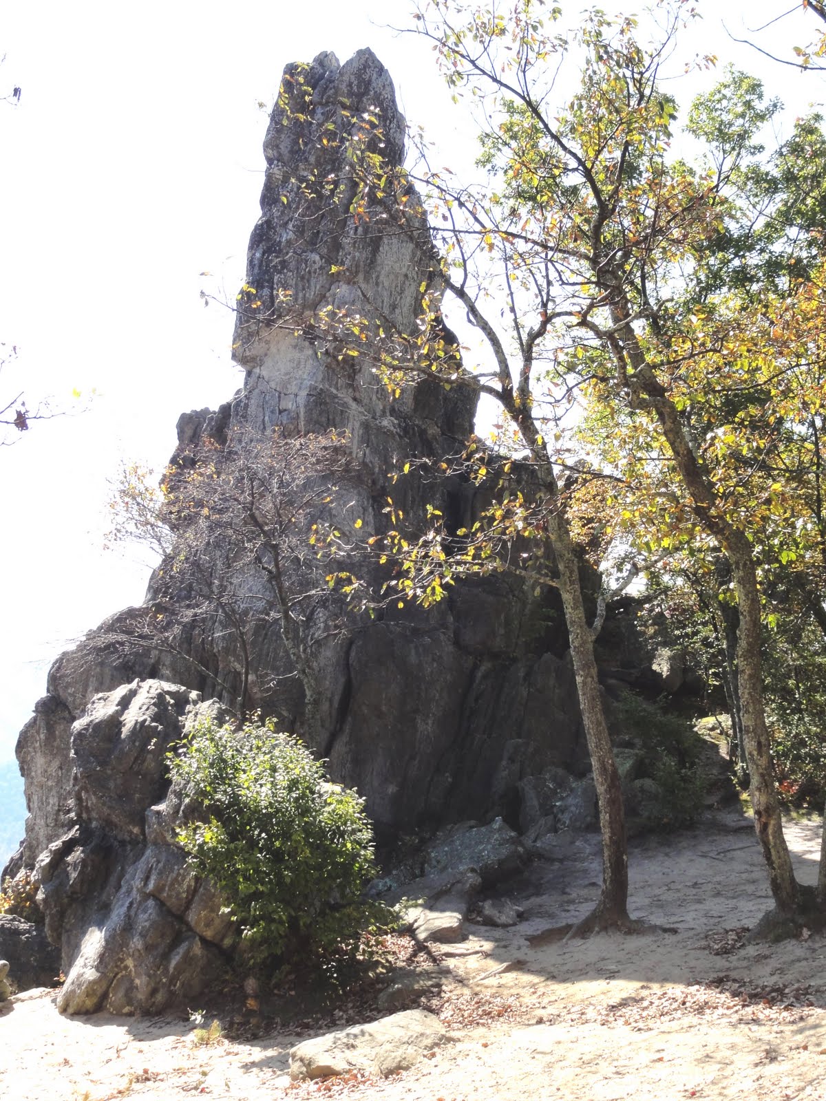
The Dragon's Tooth

One of the more challenging spots on this section of AT is the climb over "Dragon's Tooth," a jagged granite outcropping. Much of the trail requires hand over hand climbing, scooting along on your butt, and use of the rebar ladders built into the rock. Not so much fun with a 40+ lb. pack on.

In fact, a hiker was severely injured last Sunday by a fall on Dragon's Tooth. There are some nice views indeed but I wonder if the danger is worth it. I was just glad to get down off this thing.

Saturday, October 8, 2011

Jefferson National Forest


The hike out from Pearisburg goes into the Jefferson National Forest, a beautiful and remote area along the Virginia/West Virginia border. There's a lot on long ridge walks punctuated by steep, U-shaped valleys. Some parts of the At are smooth and well-designed, while others are really rough. Many of the ridges are composed of broken rock granite spines that make hiking tedious at best. And these Roanoke ATC maintainers need to learn how to build a switchback :) My body has the scars and aches to prove it.

The weather after the first day was chilly and wet--highs only around 40º on the ridges. But by Wednesday the sun was out and temps were at least 20º higher. Water sources remain a problem in the south. Many days hiking were determined by available water, sometimes over 10 miles between.

Friday, October 7, 2011

This Is Why We Hike


Started out from Pearisburg VA on Sun 10/2 on a chilly afternoon. There had been snow flurries the previous night, but as you can see from this view the weather cleared beautifully. The first climb of 1800' didn't seem too bad (thank God) and the reward was a gorgeous 12-13 mile ridge walk along the Peters Mountain Wilderness.

Saturday, September 24, 2011

It's that time again...

Hello friends,
Fall is in the air and that could mean only one thing--time to do some hiking. I've been training for the past month plus, getting ready for another Appalachian Trail adventure. Had to miss last year--2010--due to some personal issues, but I'm rearin' to go in 2011. Please stay tuned for further updates and news from the Trail. My EDT is next Sunday, Oct 02.

Friday, September 25, 2009

Jones Falls

One of the highlights of the new AT relo north of US 19E, is the side trail to Jones Falls. The video says it all.

Overmountain Shelter

Sorry for the lack of posts over the first week or so of the hike. The wet weather has forced us to keep our toys safely stowed, so we have very little photo or video documentation of our climb over the spectacular Roan Highlands. Here, on day 4, we stopped at the famous "barn", aka Overmountain Shelter for a water break. Sadly, the fog has obscured this view a bit as it did during our trek over 6200' Roan Mtn., but even a rainy day on the AT is heavenly.

Thursday, September 24, 2009

Arriving at Damascus, VA 9/24/09

Alright! 10 days and 120 miles into our hike, Harry and I reached Damascus on a warm, late summer afternoon. The ridge walk from Hampton was beautiful but we're really ready to cool our heels (literally) with some icy beverages and salads. Damascus looks pretty quiet today, but sounds like people coming in tomorrow for the weekend. I think it's good timing for a day of rest.

Thursday, September 10, 2009

It's That Time Again

I know it's been a while, but Fall is in the air and that means time to hit the trail again. I'm planning on heading out next Tuesday, Sept 15th for a month, resuming where I left off last year. I'm hoping to make it from Erwin, TN to central Virginia near Roanoke. As a special bonus feature, my good friend Harry "Zen Pig" Siegal will be joining me for the fun.

I've been training for several weeks (though not as much as I'd like) and trying to find ways in Florida to simulate the rigors of hiking the southern Appalachians. I think once we get past Roan Mtn. it will ease a bit. Probably won't post as much video this time, but I hope to give you some good moments on the blog. Until then, wish us luck.

Saturday, November 15, 2008

Epilogue: Thoughts on a Fall Hike

After all the preparations and planning, it's hard to believe the hike is already over. It's hard to briefly summarize such an experience but I've shared a few thoughts in this vid. I hope this blog hasn't spilled over into narcissism or solipsism. I really just wanted to share some of the beautiful scenery and experiences with friends who aren't fortunate enough to be there in person. And I also hope my experience encourages all of you to go for your dreams. Even if you think you're too old, too fat, too broke, too scared, too broken, too whatever, start by taking the baby steps that lead to your dreams. Life is just too short.

Even though the hiking is over, check back from time to time. I have several things to post about the AT, wilderness preservation, and environmental issues related to the trail. And there's always another season of hiking ahead. Thanks all.

Friday, November 14, 2008

The Finale, Thursday Nov 13

So, with little fanfare, I walked into Uncle Johnny's Hostel at the Chestoa Bridge around 5:20 PM. I've walked 340 miles in 27 days (plus 3 rest days) and it's been fantastic. My dear friend and mentor, Zen Pig, drove out to pick me up and greeted me with dry clothes, some OJ, and an iced coffee. On the drive back to Asheville we reflected on the transformational experience of hiking the AT. And then? Of course celebrated with a dinner at Salsa. If you gotta be civilized, that's not so bad.

Nolichucky River Gorge, final descent to Erwin Nov 13

This is the last trail video, standing on the ridge above the Nolichucky River, my destination. With the rains stopped and mostly downhill hiking, I felt great. Managed to do the 68 miles from Hot Springs in 4 days and really the only day that was rough was the 18-miler over Hogback and Big Bald. It's hard to believe my journey's almost over--I feel like I could just hike on.

Dr Pepper says hello

Making our way down the last ridgeline, Doc and I pause to check out the fog layer below us. Mercifully, the rains lasted only a couple hours, though hiking with wet feet tears them up in short time.

Don't try this at home!

I finally reached the top of Big Bald late in the day Wednesday. What a grind! Not only was I beat from a lot of uphill miles, but the weather was definitely falling apart. The winds at the summit were strong enough to blow me off the trail several times, gusting over 60 mi/hr. And chiiiiileee! I ended up hiking after dark by headlamp to reach the shelter and, man, it was a welcome sight.

view of Big Bald, Nov 12

I've reached this spot before on many day hikes, but it's a little different chugging up that grade with a full pack. You can see Big Bald Mtn. (5512') in the background, the highest point in this area with a great view. Unfortunately this section of trail borders on Wolf Laurel, a massive development with ski slopes and airplane runway. It's shameful how developers bully their way into ruining one of the formerly most beautiful, pristine views on the AT. They've already had to re-route the AT to avoid this mess. Shame, shame.

A Wintery Day on Hogback Ridge, Nov 12

Whew! After a brutal climb (1600' in 3 miles) I was pretty overheated until I reached the ridgeline and was smacked by cold, cold winds. The weather is definitely pretty threatening, and the day's 18+ mile hike is tough. Between Hogback Ridge and Big Bald there's a net elevation gain of 4000 feet. Ooof. The bonus is the wild apples, quite tasty.

Passing The 300 Mile Mark on the AT, Tue Nov 11

Yes, on Tuesday afternoon I passed the 300 mile mark right around the summit of Big Butt Mtn. in Tennessee. I must have my trail legs by now because I'm pretty consistently cranking out 16-18 mile days. After hiking solo most of the trip, I caught up to one of the few other northbounders, "Dr. Pepper" (trail name), in Hot Springs. We're hiking together to Erwin and it's good to have some company, especially since the weather is getting more difficult.

Rich Mt tower

After crossing Tanyard Gap north of Hot Springs, the AT makes a long up to Rich Mountain. The old fire tower is kinda blown out, but still has a great view. By Monday, the mild weather had turned more seasonal with clear skies, brisk winds, and cool temps. Absolutely great hiking weather in the mid-40s. In this last stretch, I need to average 17 miles a day to make Erwin by Thursday.

Leaving Hot Springs Nov 10

Even though the AT makes a sharp climb out of Hot Springs, rising out of the French Broad River gorge, it's a great piece of trail thanks to the views. About 800' above the river is a rock outcropping known as "Lover's Leap" that offers the great view seen here.

Sunday, November 9, 2008

Elmer's Sunnybank Inn, Hot Springs

It's a pretty sweet hang at Sunnybank. The Victorian structure has been a guest house for generations and a famous hiker hangout since Earl Schaeffer stayed there during his 1948 thru-hike. Elmer has a great library and cooks gourmet vegetarian meals. What an oasis on the AT!